Preparing for the unprecedented
Brian Golding
Elizabeth Ebert
David Hoffmann
Sally Potter
In 2021, several weather disasters occurred in which conditions surpassed recorded extremes. Analysis of the performance of warning systems in these disasters by the WWRP HIWeather project shows that in most, but not all cases, there was adequate forewarning of the magnitude of the event, but that lack of preparedness and/or communication failures led to loss of life in particularly vulnerable groups. Using information from the HIWeather value chain database, we present an overview of key aspects of each event – the weather and its impact, the forecasts, the warnings, and the responses – followed by some results of a comparative analysis of warning performance and some conclusions about critical components of a successful warning system. In the light of this analysis we conclude with a checklist of key components in the design of an effective warning system for unprecedented weather events.
- Article
(1352 KB) - Full-text XML
- BibTeX
- EndNote
Weather-related hazards are associated with an increasing number of recorded disasters each year (see e.g. EM-DAT, 2022), despite extensive efforts to mitigate their impacts in line with the objectives of the Sendai Framework for Disaster Risk Reduction (UNDRR, 2015). Increasing vulnerability due to a growing and increasingly urbanised global population is driving much of this increase, but a changing climate is leading to record-breaking dangerous weather conditions and weather-related hazards occurring that are outside anyone's experience. In 2021 there were many such extreme events around the world. In many cases, warnings were issued but the magnitude of the threat was not recognised, either by those issuing the warnings, or by those receiving them. Response plans did not adequately deal with these exceptional situations and people did not believe such conditions could happen where they lived.
Society protects itself from extremes to the extent that is affordable and readily manageable. As the climate changes due to global warming, extremes that were once rare enough to be ignored may become a regular threat, and some conditions that were previously considered impossible become not only possible but a threat that must be planned for.
A warning is a call to action. It can be of any lead time or confidence level. As lead time shortens, confidence and precision typically increase, justifying more costly responses. Warnings for years ahead must be very general, but can inform policy and plans, e.g. for land use planning and emergency response capacity. At seasonal to annual timescales, the level of confidence may be such as to allow plans to be reviewed and updated, while training can be refreshed. In parts of the world with significant seasonal predictability, the seasonal timescale is a key one for preparedness, particularly for floods and droughts with their attendant landslide and wildfire hazards. The first signs of a specific period of hazardous weather are often signalled at low probability in forecasts of a few weeks ahead, giving time for systems to be exercised and preventive maintenance to be carried out. A specific hazard event is usually predictable with some confidence several days in advance, enabling rosters to be adjusted for additional response capacity and early protective actions, such as reservoir draw-down or mass evacuation, to be initiated. Preparedness messaging can be delivered to those likely to be exposed to the event, to enable mitigation actions to take place. As the event approaches, increasingly detailed and confident warnings can be used to pre-position response resources and target evacuation. Finally, as the event unfolds, pinpoint accurate monitoring and nowcasting ensures response resources are targeted most effectively to minimise losses and facilitate swift recovery.
The World Meteorological Organisation, World Weather Research Programme, High Impact Weather (HIWeather) project was established in 2015 to support the improvement of weather-related warnings worldwide through targeted research. Within the project, members have been gathering, promoting and carrying out research to improve weather warnings. We have published what we have learned in our book: Towards the “Perfect” Weather Warning (Golding, 2022).
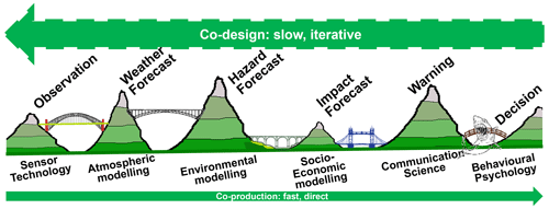
The interactions that inform a protective decision in the face of a hazard are, in reality, a complex web involving multiple information seeking and gathering routes over a substantial period of time. Their effectiveness depends both on the quality of the risk information and on the way in which it is communicated. The WWRP HIWeather project uses a highly simplified conceptual model (Fig. 1, from Golding, 2022) that represents this process as a chain of sources of expertise, connected by bridges that convey (uncertain) information in both directions. The expertise of the different actors is represented by mountains which are separated by “valleys of death” in which information can be lost if there is inadequate communication (see National Research Council, 2001 for use of this terminology). These valleys can be bridged by building partnerships among the actors concerned. While this model is inadequate to represent the full cycle of co-design and co-production that characterises the perfect warning system, it focuses on the aspect which often underlies failure, i.e. the failure of adequate communication between expert actors in the official warning production chain. Overcoming this requires partnerships to be built, which depends on significant commitment of time and resources, and so is itself often dependent on government providing a mandate for this to happen. In reality, such mandates are rarely given except after a major disaster. It is therefore important that the organisations concerned focus on making the case for partnership building, rather than simply defending themselves, in their response to a disaster.
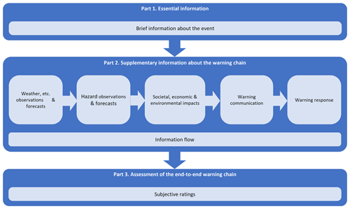
The UN Secretary General's March 2022 call for Early Warnings to protect everyone within 5 years has provided additional impetus to the work of HIWeather. To achieve the Secretary General's vision requires that the warnings are not only useful but are usable and used. The integrated view of HIWeather offers a critical viewpoint to determine where the failures of expertise and communication are occurring when warnings fail to protect people. To pursue this, the HIWeather Value Chain project is collecting data on warning events in a standard format (see Fig. 2 and Hoffmann et al., 2023) to enable comparative analysis.
4.1 Indonesia
On 4 April intense rainfall from incipient Tropical Cyclone Seroja led to flash floods and landslides in eastern Indonesia and Timor-Leste (Sekaranom et al., 2021). In Kupang City over 300 mm of rain fell in one night. In the East Flores islands whole villages were swept away. Two hundred and seventy two people were killed and there was massive damage to property and infrastructure. Warnings were issued but were not widely disseminated and did not refer to the expected impacts. Forecasts of the amount of rain diverged widely between NWP model runs.
4.2 North America
On 29 June a heat wave in the Pacific Northwest of North America produced temperatures that exceeded previous records by 5 ∘C, reaching 49 ∘C in Lytton, British Columbia. More than 1400 people died from the extreme heat. Extreme dryness helped to fuel wildfires that destroyed hundreds of square kilometres of forest. The extreme conditions were well forecast and warned several days in advance, but the most vulnerable people did not know what to do to protect themselves (Egilson, 2022).
4.3 Europe
On 15 July intense rainfall led to massive flooding in Germany, Belgium, the Netherlands, Switzerland and Luxembourg (Thieken et al., 2022), resulting in 243 fatalities. Rainfall records were broken by large margins. At Cologne 154 mm of rain fell in 24 h, exceeding the previous record of 95 mm by more than 50 %! In the upland valleys, conditions were terrifying according to interviews with flood victims and resulted in death, destruction and infrastructure failure. In the lower reaches of the rivers, there were widespread floods and damage, but residents had more time and were successfully evacuated. Warnings of exceptional rain were not translated into warnings of exceptional flood impacts.
4.4 China
On 20 July intense rainfall led to massive flooding in Henan province in China. In Zhengzhou City 201.9 mm of rain in an hour and 624.1 mm in 24 h broke records from the previous 60 years. The “sponge” city was overwhelmed and 380 people are known to have died. Warnings were issued but were not adequately translated into protective action (Guo et al., 2022; Tao and Han, 2022). Forecasts of the amount of rain diverged widely between NWP models.
4.5 Europe
On 3 August a heat wave in the central Mediterranean broke temperature records in Greece (Giannaros et al., 2022). Extreme dryness helped to fuel wildfires that destroyed hundreds of square kilometres of forest. Thousands of people had to be evacuated as the fires spread. Thick smoke hampered fire-fighting and probably caused many deaths. The extreme conditions were well forecast and warned several days in advance. The fires were on such a scale that they exceeded Greece's fire-fighting resources to tackle them.
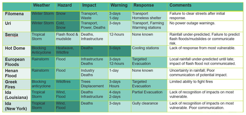
Table 1 summarises key aspects of these, and a few other, disasters. The density of the colouring in the table indicates the quality of the information communicated at each stage in the warning chain. This has been assessed subjectively, based on evidence gathered using the approach described in Hoffmann et al (this issue), relative to a “perfect” warning that would have minimised adverse impacts.
HIWeather has identified key aspects of each bridge that contribute to achieving an effective warning. Each is supported by its own body of research and is described more fully in Golding (2022). Here we present a few key indicators. Consistent with Golding (2022), we start with the user.
Help communities understand their vulnerability to extremes beyond those experienced.
In a time of change, community memory can mislead people into thinking that they understand the most extreme conditions possible, based on what has happened in the past. Communities need help to rethink what is possible in the new conditions, to understand what that might mean for them, and how they might prepare to respond.
Plan for the reasonable worst case but have a backup plan for the unreasonable case.
National governance is often couched in terms of standard operating procedures for a specific magnitude of event that is considered possible but unlikely. In a changing climate, plans based on historical precedent may be inadequate, so their sensitivity to greater threats should always be tested. Plans should be produced for a greater magnitude or higher frequency, even if it is considered outside the bounds of current possibility.
An effective warning can protect lives and property, and reduce distress and disruption.
Effective disaster risk management involves a range of policies and practices to protect or avoid disaster impacts or to transfer the impact to a less vulnerable receptor. Early warnings are a low-cost and quickly implemented contribution that can be effective if targeted at well-defined protective actions.
Involve communities in designing the warning system so that they understand and trust the advice.
There are many reasons for action not to be taken when a warning is received – failure to understand or trust the warning, absence of knowledge of suitable actions to take, and lack of resources to take them, being some of these. Most of these causes of failure can be avoided if the target community is involved in design of the warning system, including how the level of confidence should be communicated.
Use the best available forecasts to provide reliable information
Limitations in the detail or accuracy of the available information are often cited by people who did not take action. Increasing model resolution has been shown to improve accuracy, especially of extremes. Monitoring the current state is critical for predicting the immediate future (nowcasting) as well as for assimilation into models. All predictions are uncertain, and ensembles provide a key measure of the degree of uncertainty. Assess and use model data from other centres when available.
Forecast potential impacts early, to inform early actions, even when the probability is very low.
Choices of response action are driven by the impacts that we wish to avoid. At long lead times there will typically be wide uncertainty in both position and intensity of the hazard. Nevertheless, potential impacts should be forecast to inform the range of possible responses that may be required.
Communicate possible impacts and responses early, while being open about uncertainty.
Early communication of possible impacts can help responders to be able to act, and the public to be conditioned to believe a later call to act. To maintain trust, it is important to use culturally appropriate language for the uncertainty and to be open about changes in the level of risk as it evolves.
Monitor responses to early warnings and reinforce messaging when needed.
Warnings will not always result in the desired response. They may also be obscured by other news or by fake messaging. Social media provide an effective means of monitoring how people are responding. If it becomes evident that response is inappropriate, or if fake messages need to be countered, partnerships with the media should be used to reinforce the correct message.
Partnerships are critical for early actions to be effective.
Effective decisions depend on the right people having the right information in the right form at the right time and in the right place. These conditions are not likely to be met except through a joint design and production process. Information producers, communicators and decision makers have different ideas about what information is needed and how it should be communicated. These ideas are formulated and expressed in the language and culture of their discipline. Only when the different actors learn to translate between languages and cultures can they become truly effective in co-designing an effective warning system.
Behaviour of the recipient is the key success measure.
While it is important to measure the accuracy and effectiveness of each stage of the warning process, the only outcome that matters is that the recipient of the warning takes effective action to protect themselves and others. Other measures should be designed to reflect the end use of the warning.
An effective warning must be useful, usable and used.
This much-repeated maxim nicely summarises the different contributions to achieving the desired outcome of a warning. To be useful it needs to contain the information required to support the desired response. To be usable, the information must be presented in a form that reaches and is understood by the user. To be used, it must inform an action that the user is able to take.
The database questionnaire, glossary, and bibliography are publicly available at http://hiweather.net/Lists/130.html (WMO, 2023).
Conceptualization, methodology, and writing – review and editing: BG, EE, DH, and SP. Writing – original draft preparation: BG. Visualization: BG and DH. Project administration: EE, BG, SP, DH, and CM. Funding acquisition: EE, BG, SP. All authors have read the manuscript and agreed to be accountable for the content of the work.
The contact author has declared that none of the authors has any competing interests.
Publisher's note: Copernicus Publications remains neutral with regard to jurisdictional claims in published maps and institutional affiliations.
This article is part of the special issue “EMS Annual Meeting: European Conference for Applied Meteorology and Climatology 2022”. It is a result of the EMS Annual Meeting: European Conference for Applied Meteorology and Climatology 2022, Bonn, Germany, 4–9 September 2022. The corresponding presentation was part of session OSA1.2: Value Chains for Early Warning Systems.
The work described in this paper was carried out as part of the WMO WWRP High Impact Weather project (HIWeather). The authors acknowledge all of those who have contributed to HIWeather, and in particular those who contribute to the Value Chain project that is being carried out jointly with the WMO SERA working group. We also acknowledge the contributors to the HIWeather trust fund, without which the meetings and publications of HIWeather would not have been possible.
This paper was edited by Carla Mooney and reviewed by Xudong Liang and one anonymous referee.
Egilson, M.: Extreme Heat and Human Mortality: A Review of Heat-Related Deaths in B.C. in Summer 2021, https://www2.gov.bc.ca/assets/gov/birth-adoption-death-marriage-and-divorce/deaths/coroners-service/death-review-panel/extreme_heat_death_review_panel_report.pdf (last access: 20 July 2023), 2022.
EM-DAT: CRED Crunch No. 69, The interplay of drought-flood extreme events in Africa over the last twenty years (2002–2021), CRED/UCLouvain, Brussels, Belgium, https://www.emdat.be/publications/ (last access: 20 July 2023), 2022.
Giannaros, T. M., Papavasileiou, G., Lagouvardos, K., Kotroni, V., Dafis, S., Karagiannidis, A., and Dragozi, E.: Meteorological Analysis of the 2021 Extreme Wildfires in Greece: Lessons Learned and Implications for Early Warning of the Potential for Pyroconvection, Atmosphere, 13, 475, https://doi.org/10.3390/atmos13030475, 2022.
Golding, B. W. (Ed,): Towards the “Perfect” Weather Warning: bridging disciplinary gaps through partnership and communication, Springer, Cham, ISBN 978-3-030-98988-0, https://doi.org/10.1007/978-3-030-98989-7, 2022.
Guo, X., Cheng, J., Yin, C., Li, Q., Chen, R., and Fang, J.: The extraordinary Zhengzhou flood of 7/20, 2021: How extreme weather and human response compounding to the disaster, Cities, 134, 104168, https://doi.org/10.1016/j.cities.2022.104168, 2022.
Hoffmann, D., Ebert, E. E., Mooney, C., Golding, B., and Potter, S.: Using value chain approaches to evaluate the end-to-end warning chain, Adv. Sci. Res., 20, 73–79, https://doi.org/10.5194/asr-20-73-2023, 2023.
National Research Council: From Research to Operations in Weather Satellites and Numerical Weather Prediction: Crossing the Valley of Death, National Academy Press, 96 pp., ISBN 0-309-06941-6, 2001.
Sekaranom, A. B., Putri, N. H., and Puspaningrani, F. C.: The impacts of Seroja Tropical Cyclone towards extreme weather in East Nusa Tenggara, E3S Web Conf., 325, 01020, https://doi.org/10.1051/e3sconf/202132501020, 2021.
Tao, Z. and Han, L.: Emergency Response, Influence and Lessons in the 2021 Compound Disaster in Henan Province of China, Int. J. Environ. Res. Publ. Health, 19, 488, https://doi.org/10.3390/ijerph19010488, 2022.
Thieken, A. H., Bubeck, P., Heidenreich, A., von Keyserlingk, J., Dillenardt, L., and Otto, A.: Performance of the flood warning system in Germany in July 2021 – insights from affected residents, EGUsphere [preprint], https://doi.org/10.5194/egusphere-2022-244, 2022.
UNDRR: Sendai Framework for Disaster Risk Reduction 2015–2030, United Nations Office for Disaster Risk Reduction, Geneva, Switzerland, https://www.preventionweb.net/sendai-framework/sendai-framework-for-disaster-risk-reduction (last access: 20 July 2023), 2015.
WMO – World Meteorological Organization: Warning Value Chain Project, http://hiweather.net/Lists/130.html (last access: 20 July 2023), 2023.


